
I2E.png
データセットの概要より
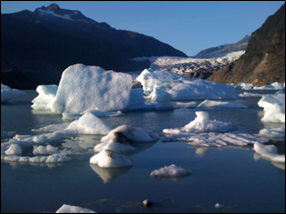
The Icefields to Estuaries map of the Southeast Alaska Coastal Module contains glaciers, estuaries, watershed boundaries, hydrology, sea surface temperatures, salinity, currents,...
追加情報
| フィールド | 値 |
|---|---|
| 最終更新日 | 2019 / 12月 / 17, |
| メタデータ最終更新日時 | 2019 / 12月 / 17, |
| 作成日 | 2019 / 12月 / 17, |
| データ形式 | image/png |
| ライセンス | ライセンスが提示されていません |
| created | 6 年以上前 |
| format | PNG |
| has views | True |
| id | e07e7c26-ae6a-4ab8-ba26-0342f69c9393 |
| last modified | 6 年以上前 |
| mimetype | image/png |
| on same domain | True |
| package id | 0bcbede9-c9f2-4a83-a68a-fe7650ec46bb |
| position | 3 |
| revision id | ce9d1110-a65a-452c-9c22-f536555fe9c4 |
| size | 156.3 KiB |
| state | active |
| url type | upload |